Water Across the Empire: Roman Aqueducts and the Hydraulic Logic of Conquest
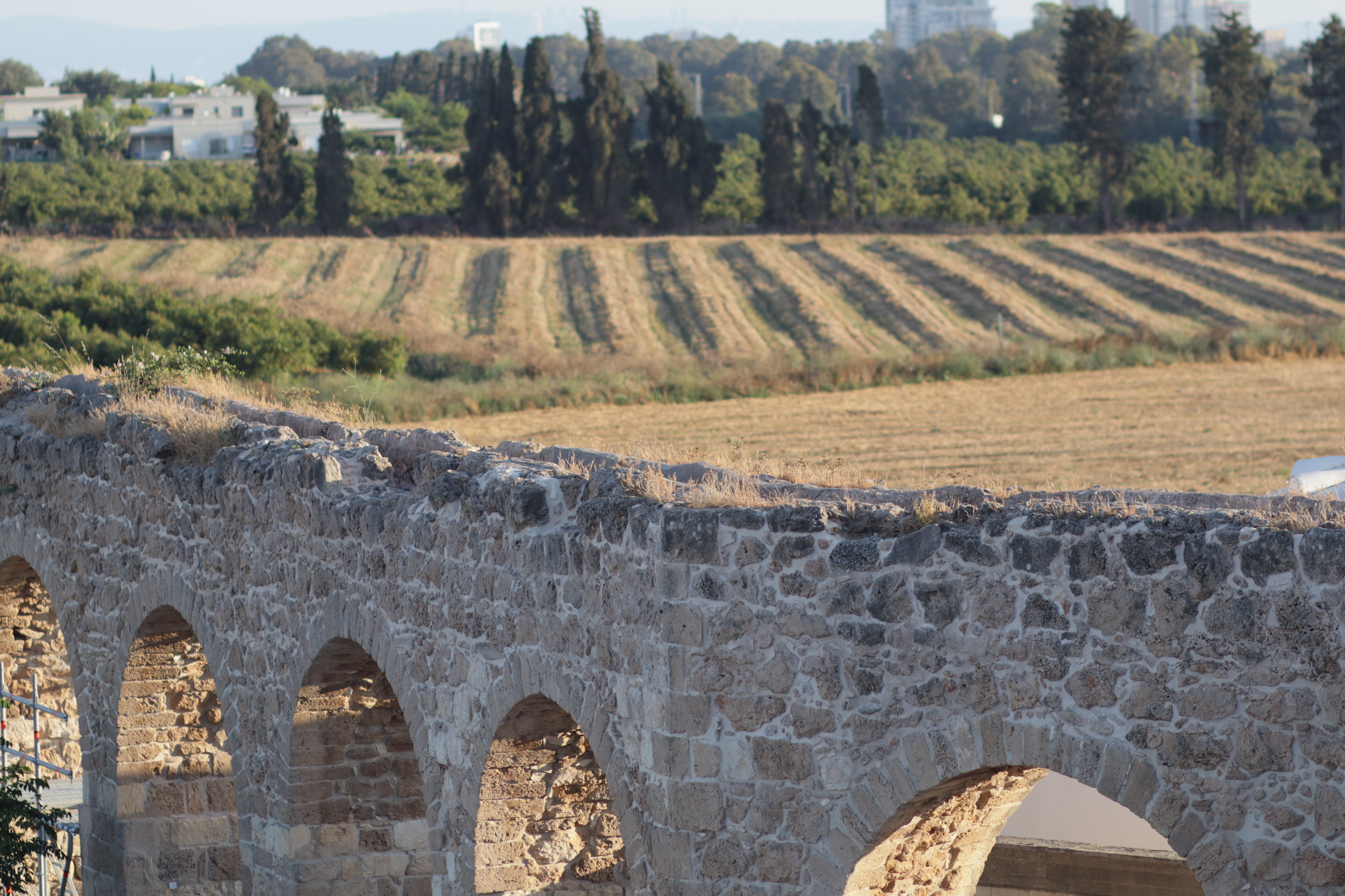
The stone arch does not announce itself. It simply continues — span after span across flat agricultural land, indifferent to the centuries accumulating around it. The aqueduct near Nahariya in western Galilee, its kurkar limestone worn to the color of dry earth, carried water to the coastal settlements of ancient Ptolemais long before the Crusaders reinforced its arches and the Ottomans extended its reach. That layering is not incidental. It is the story of Roman hydraulic engineering in miniature: infrastructure so rationally conceived that every subsequent empire found it easier to inherit than to replace.
Rome did not invent the aqueduct. The Assyrians built one at Jerwan in the eighth century BCE. Carthaginian engineers understood gravity-fed conduits. But Rome systematized the technology, embedded it in law, staffed it with professional curatores aquarum, and replicated it from Hispania to the Euphrates with a consistency that amounted to a hydraulic ideology. Water was not incidental to Roman urbanism. It was the precondition for it.
Engineering the Gradient
The governing principle of Roman aqueduct construction was deceptively simple: water moves downhill. The engineering challenge was maintaining a usable gradient — typically between 1-in-200 and 1-in-4,800 — across terrain that offered no such convenience. The Aqua Claudia in Rome descended roughly 68 meters over 69 kilometers. The aqueduct supplying Carthage, at 132 kilometers one of the longest in the empire, maintained gradients precise enough to sustain flow across the high plains of what is now Tunisia without pumping of any kind.
To hold the gradient over uneven ground, Roman engineers employed three solutions: cut-and-cover channels buried in hillsides, tunnels bored through ridges, and the elevated arcade — the arched bridge that has become the visual shorthand for Roman engineering itself. The arcade was expensive. Stone, labor, and the geometric problem of centering arches over long spans made it the last resort rather than the first. Engineers preferred to hug topography. Where the land fell away and there was no alternative, they built upward.
The arches near Nahariya represent exactly this calculus. The coastal plain of western Galilee offered no convenient ridge to carry a channel at the required elevation. The arcade was the answer: a structure that is, at its core, a mechanism for maintaining a fictitious hillside across a gap the real terrain refused to provide.
The Province of Judaea and Its Water
Rome conquered Judaea under Pompey in 63 BCE and administered it as a province from 6 CE — Provincia Judaea — governing a territory whose existing hydraulic infrastructure was already sophisticated. Hasmonean tunnels, Herodian reservoirs, Nabataean cisterns: the Romans arrived in a landscape where water management had been a political and engineering priority for centuries. They absorbed what was there and built on it.
The province’s hydraulic centerpiece was Caesarea Maritima, Herod’s artificial port city on the Sharon coast, which received an aqueduct from springs in the Carmel range — a project Herod initiated and Hadrian extended. Jerusalem’s Temple Mount complex depended on an elaborate cistern network fed by aqueducts from the Hebron hills, some sections of which remained functional into the twentieth century. The Roman administration inherited these systems, maintained them where useful, and augmented them where population growth or military necessity demanded.
The installations serving Ptolemais — the Hellenistic name for what is now Akko — fit this pattern exactly. Ptolemais was a port and military staging ground of consistent strategic value, used by Alexander, held by the Ptolemies, and recognized by Rome as a city that could not be garrisoned and resupplied without reliable water. The infrastructure built to serve it ran through the landscape now occupied by modern Nahariya. Its arches outlasted the legions that commissioned them by nearly two millennia.
A note on terminology: calling this region “Roman Palestine” imports a name that did not exist until 135 CE, when Hadrian renamed the province Syria Palaestina after crushing the Bar Kokhba revolt — a deliberate administrative act of erasure, reviving a Greek toponym derived from the Philistines to suppress Jewish connection to the land. Projecting that name backward across the entire Roman period is both historically inaccurate and carries the weight of a punitive renaming. The province was Judaea. The infrastructure served Judaea.
Maintenance, Law, and the Political Economy of Water
Roman aqueducts did not run themselves. The Frontinus treatise De Aquaeductu, written around 97 CE by the curator aquarum Sextus Julius Frontinus, documents an administrative apparatus of considerable sophistication: recorded flow rates, legal prohibitions on unauthorized tapping, maintenance schedules for settling tanks and distribution castella. Frontinus calculated that illegal diversions had reduced Rome’s effective water supply by a measurable fraction and proposed enforcement as an infrastructure investment.
In the provinces, the administrative picture was less tidy but the principle held. Municipal water supplies were assets. Damage to conduits was a legal offense. Cities competed for imperial favor partly through the quality and scale of their hydraulic infrastructure, and benefactors who funded aqueduct construction expected the commemorative inscriptions to survive as long as the stone.
The Nahariya aqueduct’s later history — Crusader reinforcement, Ottoman rehabilitation — confirms what the Roman engineers apparently understood from the beginning: that the limiting factor in hydraulic infrastructure is not the initial construction but the sustained political will to maintain it. When that will collapsed with the Western empire in the fifth century, the aqueducts of Rome itself fell silent within decades. The channels were intact. The maintenance was not.
What Survives
The arched spans near Nahariya stand in a landscape that has reorganized itself entirely around concerns the Roman engineers could not have anticipated. Agricultural fields stretch behind the arcade in rows the Roman surveyors would have recognized as rational land use. Modern structures crowd the treeline in the background. The aqueduct itself is fenced, studied, preserved as heritage — a category of attention the Romans reserved for temples and triumphal monuments, not water pipes.
That reframing is worth noting. Roman aqueducts were not built to be admired. They were built to move water from an elevation to a population, reliably, across terrain that would otherwise prevent it. The fact that they now function primarily as objects of contemplation — that we photograph them, write about them, route tourists past them — is a consequence of their durability, not their intent. The intent was purely functional: water in, city viable, province held.
The arch doesn’t know the difference. It continues to stand on the same logic it was built on: that a curved assembly of cut stone, properly centered and loaded, will hold indefinitely under its own weight. Two thousand years is an acceptable proof of concept.
The aqueduct near Nahariya preserves sections of the Roman and later infrastructure that supplied ancient Ptolemais (Akko) on Israel’s western Galilee coast, in the Roman province of Judaea.